With nothing productive I could do on the farm, we all drove into town (Gympie)this morning to check on the rising flood levels. At my place, we have had >300mm of rain in 3 days. I say ">" as the rain gauge which holds 190mm, overflowed for who knows how long one night!
Gympie has been through many floods in past decades, and the people know the drill on precautions. This afternoon, businesses in the main street (Mary St) were evacuating their goods and shop fittings. Unfortunately for Mary Street, it is one of the lower areas of Gympie, and is often in peril from flood waters during severe rains. Some of the older locals have been warning of impending serious flooding for some time now, as they believed it to be far overdue!.
The following is the latest weather report for outlook:
Very heavy rainfall of up to 190 millimetres has been recorded in the headwaters of the Mary River since 9am this morning and rainfall is expected to continue during Sunday night. Renewed rises are expected at Gympie during Sunday night with major flood levels expected during Monday. At Gympie, river levels will start rising during Sunday night and reach the
major flood level of 17 metres early Monday morning and continue rising during
Monday. It is not possible to provide a peak forecast at this stage as heavy
rainfall continues in the catchment.
Predicted River Heights/Flows:
Gympie: Exceed 17 metres early Monday.
Higher levels expected during Monday.
It is not possible to provide a peak forecast at this stage as heavy rainfall
continues in the catchment.
Anyone interested in following flooding status can do so on :
http://www.bom.gov.au and select "Queensland (or QLD)". Radar images are available, as is the latest forceasts of flood areas and road closures.
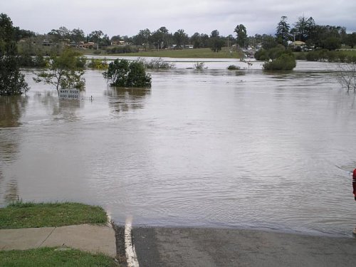
This is what the Mary River looks like when angry! Normally the river is around 10-15 feet BELOW the bridge. This photo is from a very minor flood last year. No homes or businesses were damaged. This morning I took video of the same location, and the waters are approximately 6 feet higher already.
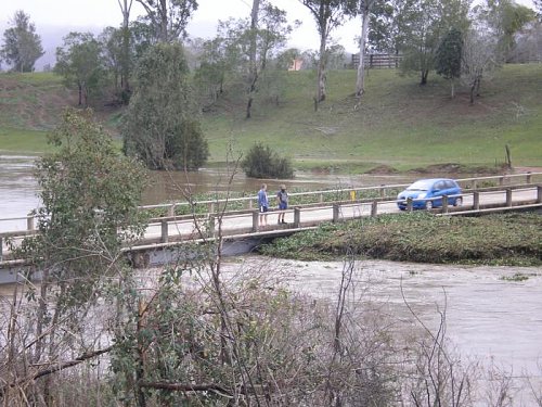
This photo is of Bell's Bridge, 5 min north of Gympie, just before it went under water. For some reason, these fellows thought it a good idea to stop and have a really good look. Once again, this photo is from the earlier flooding. Today this bridge is fully submerged, and apart from the approach roads, there is no evidence of it's presence.
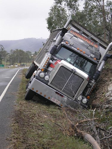
The driver of this truck encountered rain so heavy he had to stop driving and pull to the side of the road. Due to the rain, he was not able to know that the road shoulder was so saturated that his truck sank to the extent it would have rolled over if no embankment was able to lend a supportive hand
Perhaps for the truck driver it was
'a shoulder to cry on'. Sorry, couldn't help myself!
I will take my camera with me tomorrow, and hope to take some interesting photos worthy of posting.